ハイパースペクトル イメージ処理
Hyperspectral Imaging Library for Image Processing Toolbox™ は、ハイパースペクトル イメージおよびマルチスペクトル イメージを処理および可視化するための MATLAB® 関数とツールを提供します。
このライブラリの関数を使用して、ハイパースペクトル イメージング センサーおよびマルチスペクトル イメージング センサーを使用して取得した、さまざまなファイル形式のデータの読み取り、書き込み、および処理を行います。このライブラリは、NITF (National Imagery Transmission Format)、ENVI (Environment for Visualizing Images)、TIFF (Tagged Image File Format)、MTL (Metadata Text Extension)、HDF (Hierarchical Data Format)、および SAFE (Standard Archive Format for Europe) ファイル形式をサポートしています。
このライブラリは、バンド選択、ノイズ除去、ラジオメトリック補正と大気補正、次元削減、エンドメンバーの抽出、存在量マップの推定、スペクトル マッチング、異常検出、スペクトル インデックスの計算、およびセグメンテーションのための一連のアルゴリズムを提供します。
ハイパースペクトル ビューアー アプリを使用して、ハイパースペクトル データおよびマルチスペクトル データの読み取り、メタデータおよび地理空間情報の表示、個々のバンド イメージおよびそのヒストグラムの可視化、データ キューブ内のピクセルまたは領域のスペクトル プロットの作成、エンドメンバーのプロット、異なるカラー表現またはフォールス カラー表現の生成、スペクトル インデックスの計算、および結果のエクスポートを行うことができます。
ハイパースペクトル イメージおよびマルチスペクトル イメージの解析を実行するには、アドオン エクスプローラーから Hyperspectral Imaging Library for Image Processing Toolbox をダウンロードします。アドオンのダウンロードの詳細については、アドオンの入手と管理を参照してください。
アプリ
| ハイパースペクトル ビューアー | ハイパースペクトル データおよびマルチスペクトル データの可視化 |
| スペクトル イメージ ラベラー | Label hyperspectral and multispectral images (R2026a 以降) |
関数
トピック
開始
- Get Started with Hyperspectral and Multispectral Image Processing
Basics of hyperspectral and multispectral image processing. - Analyze Hyperspectral and Multispectral Images
Describes approaches to hyperspectral and multispectral imaging. - Explore Hyperspectral and Multispectral Data in the Hyperspectral Viewer
This example shows how to explore hyperspectral and multispectral data using the ハイパースペクトル ビューアー app. - Get Started with Spectral Image Labeler
Interactively label hyperspectral and multispectral images. - Process Large Hyperspectral and Multispectral Images
This example shows how to process small regions of large hyperspectral and multispectral images. - Hyperspectral and Multispectral Data Correction
Describes radiometric calibration, atmospheric correction, and spectral correction. - Spectral Matching and Target Detection Techniques
Techniques for target detection and spectral matching. - Spectral Indices
Describes spectral indices. - Support for Singleton Dimensions
Analysis of 1-D and 2-D spectral data using singleton hypercube.
分類
- ライブラリ シグネチャと SAM を使用したハイパースペクトル イメージの分類
スペクトル角マッパー (SAM) 分類アルゴリズムを使用して、ハイパースペクトル イメージ内のピクセルを分類する。 - 深層学習を使用したハイパースペクトル イメージの分類
この例では、カスタム スペクトル畳み込みニューラル ネットワーク (CSCNN) を使用してハイパースペクトル イメージの分類を行う方法を説明します。 - サポート ベクター マシン分類器を使用したハイパースペクトル イメージの分類
この例では、サポート ベクター マシン (SVM) 分類器を使用してハイパースペクトル イメージの分類を実行する方法を示します。
領域の識別
- スペクトル シグネチャ マッチングを使用したターゲットの検出
スペクトル マッチング法を使用して、ハイパースペクトル イメージ内の既知のターゲットを検出する。 - Identify Vegetation Regions Using Interactive NDVI Thresholding
Identify the types of vegetations regions in a hyperspectral image through interactive thresholding of a normalized difference vegetation index (NDVI) map. - Find Regions in Spatially Referenced Multispectral Image
This example shows how to identify water and vegetation regions in a Landsat 8 multispectral image and spatially reference the image.
デジタル ツイン
- Generate RoadRunner Scene Using Aerial Hyperspectral and Lidar Data (Automated Driving Toolbox)
Generate RoadRunner scene from aerial hyperspectral and lidar data.
セグメンテーション
- Segment Hyperspectral Image Using Segment Anything Model in Spectral Image Labeler
This example shows how to write a custom automation algorithm for segmenting hyperspectral images and use it in the Spectral Image Labeler app. - Interactively Segment Hyperspectral Image Using Segment Anything Model
This example shows how to interactively preprocess and segment a hyperspectral image using the Segment Anything Model (SAM). (R2025a 以降)
注目の例
Combine Landsat 9 Multispectral Images Using Image Mosaicing
Stitch multiple Landsat 9 multispectral images into a mosaic image and analyze the mosaic image.
Predict Sugar Content in Grape Berries Using PLS Regression on Hyperspectral Data
Perform non-destructive testing (NDT) using hyperspectral data to predict sugar content in grape berries.

Classify Land Cover Using Hyperspectral and Lidar Data
Classify land cover using a fusion of hyperspectral and lidar data.

Segment Spleen in Hyperspectral Image of Porcine Tissue
Segment a spleen in a hyperspectral image of porcine tissue.

Classify Land Cover Using Sentinel-2 Multispectral Images
Fine-tune a pretrained segmentation model backbone, using Sentinel-2 Level 2A multispectral images and CORINE Land Cover 2018 data, for pixel-level land-cover classification.

Ship Detection from Sentinel-1 C Band SAR Data Using YOLOX Object Detection
Detect ships from Sentinel-1 C Band SAR Data using YOLOX object detection.

Map Flood Areas Using Sentinel-1 SAR Imagery
Map flooded areas using Sentinel-1 Synthetic Aperture Radar (SAR) images.

Change Detection in Hyperspectral Images
Detect changes in land cover from hyperspectral images taken at different times.

Manually Label ROIs in Multispectral Image
Manually select regions of interest (ROIs) from a multispectral image and save them in a shapefile.
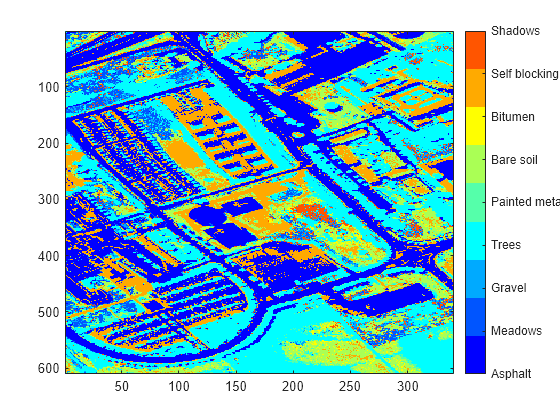
最大存在量分類を使用したハイパースペクトル イメージ解析
この例では、最大存在量分類 (MAC) を実行して、ハイパースペクトル イメージ内のさまざまな領域を識別する方法を示します。存在量マップは、ハイパースペクトル イメージ全体でエンドメンバー分布の特徴を表すものです。イメージ内の各ピクセルは、"ピュア ピクセル" の場合や "ミクセル" の場合があります。各ピクセルについて取得した存在量値のセットは、そのピクセルに存在する各エンドメンバーの割合を表しています。この例では、ピクセルごとの最大存在量値を見つけ、それを関連するエンドメンバー クラスに割り当てることでハイパースペクトル イメージ内のピクセルを分類します。

スペクトル ライブラリを使用したエンドメンバー物質の同定
ハイパースペクトル イメージ内に存在するエンドメンバー物質のクラスを同定する。

Automate Pixel Labeling of Hyperspectral Images Using Image Labeler
Load hyperspectral images into the イメージ ラベラー (Computer Vision Toolbox) and automatically label pixels.