LiDAR 点群データの読み取り、処理、書き込み
この例では、点群をワークスペースに読み取り、目的の点集合を選択して、選択された点を点群ファイルの形式に書き込む方法を示します。
手順 1: 点群の読み取りと表示
関数 lasFileReader を使用して、.las ファイルからワークスペースにデータを読み取ります。出力 lasFileReader オブジェクトに格納されたプロパティを表示します。
fileName = fullfile(toolboxdir("lidar"),"lidardata","las","aerialLidarData.laz");
lasReader = lasFileReader(fileName)
lasReader =
  lasFileReader with properties:

                    Count: 1018047
                  XLimits: [4.2975e+05 4.3015e+05]
                  YLimits: [3.6798e+06 3.6801e+06]
                  ZLimits: [72.7900 125.8200]
               Attributes: ["Classification"    "LaserReturn"    "NumReturns"    "ScanDirectionFlag"    "EdgeOfFlightLineFlag"    "ScanAngle"    "UserData"    "PointSourceID"    "GPSTimeStamp"]
       ClassificationInfo: "To get the value, enter lasReader.ClassificationInfo at the Command Window. Learn more"
          LaserReturnInfo: [4×2 table]
    VariableLengthRecords: [3×3 table]

  Show all properties
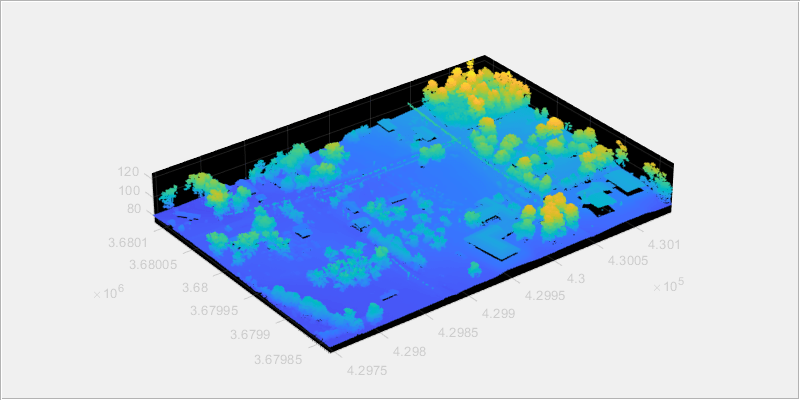
.las ファイルから点群を読み取ります。
ptCloud = readPointCloud(lasReader);
点群を表示します。
fig = figure(Position=[0 0 800 400]);
hPanel = uipanel(fig);
hPlot = axes(hPanel);
pcshow(ptCloud.Location,Parent=hPlot)
手順 2: 目的の点集合の選択
オブジェクト クラスの分類値および関心領域 (ROI) 内の点のインデックスを指定して、入力点群から目的の点集合を選択できます。
分類値の指定による点の選択
分類値を指定して点を選択するには、
lasFileReaderオブジェクトのClassificationInfoプロパティを使用して入力点群のオブジェクト クラスに関する情報を読み取ります。
disp(lasReader.ClassificationInfo)
    Classification Value        Class Name         Number of Points by Class
    ____________________    ___________________    _________________________

             1              "Unclassified"                  114842
             2              "Ground"                        646632
             4              "Medium Vegetation"             210101
             6              "Building"                       45699
             8              "Reserved(8)"                      751
             9              "Water"                             22
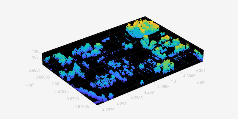
関数
readpointCloudを使用して、入力点群から読み取るオブジェクト クラスの分類値を指定します。中植生領域に対応する点を読み取るには、名前と値の引数Classificationの値を 4 に設定します。
ptCloudB = readPointCloud(lasReader,Classification=4);
点群を表示します。
fig1 = figure(Position=[0 0 800 400]);
hPanel1 = uipanel(fig1);
hPlot1 = axes(hPanel1);
pcshow(ptCloudB.Location,Parent=hPlot1)
インデックスの指定による点の選択
入力点群の "x" 座標、"y" 座標、"z" 座標の範囲内で直方体 ROI を定義します。
roi = [lasReader.XLimits(1)+200, lasReader.XLimits(2), ...
    lasReader.YLimits(1), lasReader.YLimits(2), lasReader.ZLimits(1), lasReader.ZLimits(2)];
直方体 ROI の中にある点のインデックスを調べます。
indices = findPointsInROI(ptCloudB,roi);
直方体 ROI の中にある点を選択し、点群オブジェクトとして格納します。
ptCloudC = select(ptCloudB,indices);
点群を表示します。
fig2 = figure(Position=[0 0 800 400]);
hPanel2 = uipanel(fig2);
hPlot2 = axes(hPanel2);
pcshow(ptCloudC.Location,Parent=hPlot2)

手順 3: 選択された点の .las ファイル形式への書き込み
.las ファイルの名前を指定し、lasFileWriter オブジェクトを作成します。
newfileName = "aerialvegetation.las";
lasWriter = lasFileWriter(newfileName);
関数 writePointCloud を使用して、選択された点を .las ファイルに書き込みます。この関数は、現在の作業ディレクトリに新しいファイルを作成します。
writePointCloud(lasWriter,ptCloudC);
手順 4: 新規に書き込んだファイルのプロパティの確認
newlasReader = lasFileReader(newfileName)
newlasReader =
  lasFileReader with properties:

                    Count: 116598
                  XLimits: [4.2995e+05 4.3015e+05]
                  YLimits: [3.6798e+06 3.6801e+06]
                  ZLimits: [84.9500 123.1100]
               Attributes: ["Classification"    "LaserReturn"    "NumReturns"    "ScanDirectionFlag"    "EdgeOfFlightLineFlag"    "ScanAngle"    "UserData"    "PointSourceID"    "GPSTimeStamp"    "ScannerChannel"]
       ClassificationInfo: "To get the value, enter newlasReader.ClassificationInfo at the Command Window. Learn more"
          LaserReturnInfo: [1×2 table]
    VariableLengthRecords: [1×3 table]

  Show all properties
参考
lasFileReader | pcshow | readPointCloud | findPointsInROI | pointCloud | select