geolineshape
Description
A geolineshape object represents a line or multiline in
geographic coordinates. A multiline is an individual line shape that
contains a set of separate lines.
To represent a line or multiline in planar coordinates, use a maplineshape object
instead.
Creation
To create geolineshape objects, either:
Import line data in geographic coordinates as a geospatial table using the
readgeotablefunction, and then query theShapevariable of the table.Use the
geolineshapefunction (described here).
Description
Input Arguments
Properties
Object Functions
Examples
Import the tracks layer of a GPX file containing routes in Massachusetts as a geospatial table. The tracks layer represents the routes using lines. Get information about the line in the second track by querying the Shape variable of the table.
GT = readgeotable("sample_tracks.gpx",Layer="tracks");
GT.Shape(2)
ans =
  geolineshape with properties:

                NumParts: 5
                Geometry: "line"
    CoordinateSystemType: "geographic"
           GeographicCRS: [1×1 geocrs]
Create a subtable that contains the second track. Display the second track on a road map.
GT2 = GT(2,:);
geoplot(GT2,LineWidth=2)
geobasemap streets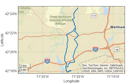
Create an individual line as a geolineshape scalar. Specify the geographic CRS as the World Geodetic System of 1984, which has the EPSG code 4326.
lat = [65 62 53 66];
lon = [4 59 121 98];
lineshp = geolineshape(lat,lon);

g = geocrs(4326);
lineshp.GeographicCRS = g
lineshp =
  geolineshape with properties:

                NumParts: 1
                Geometry: "line"
    CoordinateSystemType: "geographic"
           GeographicCRS: [1×1 geocrs]
Create a multiline as a geolineshape scalar.
lat = [55 34 18 NaN 14 19 42 26];
lon = [78 56 63 NaN 83 106 104 126];
multiline = geolineshape(lat,lon);
multiline.GeographicCRS = g
multiline =
  geolineshape with properties:

                NumParts: 2
                Geometry: "line"
    CoordinateSystemType: "geographic"
           GeographicCRS: [1×1 geocrs]
Create one individual line and one multiline as a 1-by-2 geolineshape array.
lat = {[55 34 18],[14 19 NaN 42 26 37]};
lon = {[78 56 63],[83 106 NaN 104 126 113]};
lineMultiline = geolineshape(lat,lon);
lineMultiline.GeographicCRS = glineMultiline=1×2 geolineshape array with properties:
NumParts: [1 2]
Geometry: "line"
CoordinateSystemType: "geographic"
GeographicCRS: [1×1 geocrs]
Version History
Introduced in R2021b