このページは機械翻訳を使用して翻訳されました。最新版の英語を参照するには、ここをクリックします。
衛星シナリオのモデル化、可視化、および解析
この例では、軌道上の衛星をモデル化し、衛星と地上局間のアクセスを解析し、衛星の視野と地上経路を可視化する方法を示します。
衛星シナリオの作成
開始時刻が 2020 年 6 月 2 日午前 8 時 23 分 (UTC)、終了時刻が 5 時間後の衛星シナリオを作成します。シミュレーションのサンプル時間を 60 秒に設定します。
startTime = datetime(2020,6,02,8,23,0);
stopTime = startTime + hours(5);
sampleTime = 60;
sc = satelliteScenario(startTime,stopTime,sampleTime);
シナリオに衛星を追加する
threeSatelliteConstellation TLEファイルからシナリオに衛星を追加します。
sat = satellite(sc,"threeSatelliteConstellation.tle");軌道上の衛星を表示し、20 分間のグラウンド トラックをプロットします。
show(sat)
groundTrack(sat,"LeadTime",1200);
衛星の軌道要素と位置を返す
シナリオ内の各衛星の軌道要素を表示します。
ele1 = orbitalElements(sat(1))
ele1 = struct with fields:
                       MeanMotion: 0.0525
                     Eccentricity: 1.0000e-03
                      Inclination: 55
    RightAscensionOfAscendingNode: 175.0000
              ArgumentOfPeriapsis: 100
                      MeanAnomaly: 174.9900
                           Period: 6.8557e+03
                            Epoch: 02-Jun-2020 18:43:16
                            BStar: 1.0000e-04
ele2 = orbitalElements(sat(2))
ele2 = struct with fields:
                       MeanMotion: 0.0487
                     Eccentricity: 1.0000e-03
                      Inclination: 55
    RightAscensionOfAscendingNode: 350.0000
              ArgumentOfPeriapsis: 90
                      MeanAnomaly: 310.0877
                           Period: 7.3898e+03
                            Epoch: 02-Jun-2020 18:33:26
                            BStar: 1.0000e-04
ele3 = orbitalElements(sat(3))
ele3 = struct with fields:
                       MeanMotion: 0.0496
                     Eccentricity: 1.0000e-03
                      Inclination: 55
    RightAscensionOfAscendingNode: 270
              ArgumentOfPeriapsis: 95
                      MeanAnomaly: 119.9007
                           Period: 7.2550e+03
                            Epoch: 02-Jun-2020 18:37:40
                            BStar: 1.0000e-04
2020 年 6 月 2 日PM12 時 30 分 UTC における最初の衛星の緯度、経度、高度を返します。
time = datetime(2020,6,02,12,30,0);
pos = states(sat(1),time,"CoordinateFrame","geographic")
pos = 3×1
106 ×

    0.0000
   -0.0001
    1.4212
地上局を追加する
関心のある地上局として、マドリードとキャンベラの深宇宙通信複合施設の緯度と経度を指定します。
name = ["Madrid Deep Space Communications Complex", ...
      "Canberra Deep Space Communications Complex"];
lat = [40.43139, -35.40139];
lon = [-4.24806, 148.98167];
gs = groundStation(sc,"Name",name,"Latitude",lat, ...
    "Longitude", lon);
指定した時間の方位角角、仰角、距離を返します
2020 年 6 月 2 日PM12 時 30 分 (UTC) の時点におけるマドリード深宇宙通信複合施設に対する最初の衛星の方位角角、仰角、および範囲を返します。
time = datetime(2020,6,02,12,30,0);
[az,elev,r] = aer(gs(1),sat(1),time)
az = 264.2457
elev = -34.0669
r = 9.3088e+06
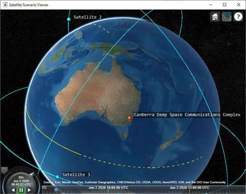
衛星と地上局を使用して衛星シナリオを再生します。
play(sc)
参考
オブジェクト
satelliteScenario|satellite|Access|GroundStation|satelliteScenarioViewer|ConicalSensor|Transmitter|Receiver