メインコンテンツ
結果 7 件
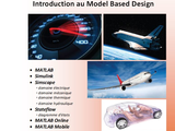
Présentation du potentiel de MATLAB dans le cadre de la modélisation multi-physique

3D plot of GPS location and Overlay the GPS data on map
Activity Detection in MATLAB

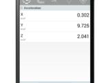
MATLAB mobile is used to collect the sensor data while traveling along a road which is used to analyze road profile and congestion.
Shows how to save/update mobile phone sensors' logs to MATLAB Drive continuously (sensors.m) and access this data from PC (plotsensors.m)
Step-by-step process files and sample example code, to create your own Fitness tracker with MATLAB Online and MATLAB Mobile

Use MATLAB Mobile™ to complete end-to-end quantitative analysis and visualization sharing of running data
また、以下のリストから Web サイトを選択することもできます。
南北アメリカ
- América Latina (Español)
- Canada (English)
- United States (English)
ヨーロッパ
- Belgium (English)
- Denmark (English)
- Deutschland (Deutsch)
- España (Español)
- Finland (English)
- France (Français)
- Ireland (English)
- Italia (Italiano)
- Luxembourg (English)
- Netherlands (English)
- Norway (English)
- Österreich (Deutsch)
- Portugal (English)
- Sweden (English)
- Switzerland
- United Kingdom(English)
アジア太平洋地域
- Australia (English)
- India (English)
- New Zealand (English)
- 中国
- 日本Japanese (日本語)
- 한국Korean (한국어)