show
Description
AX = show(mission)AX that contains the plot.
AX = show(___,Name=Value)show(mission,ReferenceLocation=[0 0 0]) shows the mission with the
reference location set to [0 0 0].
Examples
Create a UAV mission object with a home location at the origin of the local ENU coordinate frame and an initial speed of 5 meters per second.
m = uavMission(Frame="LocalENU",HomeLocation=[0 0 0],Speed=5)m =
uavMission with properties:
HomeLocation: [0 0 0]
InitialYaw: 0
Frame: "LocalENU"
Speed: 5
NumMissionItems: 0
Add a takeoff mission item to the mission with an altitude of 25 meters, pitch of 15 degrees, and yaw of 0 degrees.
addTakeoff(m,20,Pitch=15,Yaw=0);
Add two waypoint mission items to the mission. Between the two waypoints, increase the speed of the UAV to 20 meters per second. After the second waypoint, reduce the speed of the UAV back to 5 meters per second.
addWaypoint(m,[10 0 30]);
addChangeSpeed(m,20)
addWaypoint(m,[20 0 40]);
addChangeSpeed(m,5)
addWaypoint(m,[30 0 50])
Add loiter and hover mission items to the mission, specifying for the UAV to loiter and hover around the second waypoint at a radius of 50 meters for 20 seconds each.
addLoiter(m,[40 0 60],10,20);
addHover(m,[50 0 70],10,20);
Add a landing mission item to the mission to land the UAV.
addLand(m,[70 0 0],Yaw=0);
Show the mission item data table.
showdetails(m)
ans=9×17 table
    Idx    Timestamp     MissionType     ParameterName1    ParameterValue1    ParameterName2    ParameterValue2    ParameterName3    ParameterValue3    ParameterName4    ParameterValue4      ParameterName5      ParameterValue5    ParameterName6    ParameterValue6    ParameterName7    ParameterValue7
    ___    _________    _____________    ______________    _______________    ______________    _______________    ______________    _______________    ______________    _______________    __________________    _______________    ______________    _______________    ______________    _______________

     1        NaN       "Takeoff"          "Altitude"            20              "Pitch"               15              "Yaw"                 0             ""                   NaN          ""                          NaN                ""                NaN                ""                NaN
     2        NaN       "Waypoint"         "X"                   10              "Y"                    0              "Z"                  30             "Yaw"                NaN          "AcceptanceRadius"          NaN                ""                NaN                ""                NaN
     3        NaN       "ChangeSpeed"      "Speed"               20              ""                   NaN              ""                  NaN             ""                   NaN          ""                          NaN                ""                NaN                ""                NaN
     4        NaN       "Waypoint"         "X"                   20              "Y"                    0              "Z"                  40             "Yaw"                NaN          "AcceptanceRadius"          NaN                ""                NaN                ""                NaN
     5        NaN       "ChangeSpeed"      "Speed"                5              ""                   NaN              ""                  NaN             ""                   NaN          ""                          NaN                ""                NaN                ""                NaN
     6        NaN       "Waypoint"         "X"                   30              "Y"                    0              "Z"                  50             "Yaw"                NaN          "AcceptanceRadius"          NaN                ""                NaN                ""                NaN
     7        NaN       "Loiter"           "X"                   40              "Y"                    0              "Z"                  60             "Radius"              10          "Duration"                   20                ""                NaN                ""                NaN
     8        NaN       "Hover"            "X"                   50              "Y"                    0              "Z"                  70             "Radius"              10          "Duration"                   20                ""                NaN                ""                NaN
     9        NaN       "Land"             "X"                   70              "Y"                    0              "Z"                   0             "Yaw"                  0          ""                          NaN                ""                NaN                ""                NaN
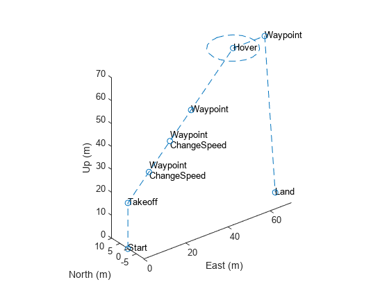
Remove the hover action at index 7, and then add another waypoint at index 8 after the hover item moves to index 7. Show the mission details table again to see the changes.
removeItem(m,7);
addWaypoint(m,[65 0 70],InsertAtRow=8);
showdetails(m)
ans=9×17 table
    Idx    Timestamp     MissionType     ParameterName1    ParameterValue1    ParameterName2    ParameterValue2    ParameterName3    ParameterValue3    ParameterName4    ParameterValue4      ParameterName5      ParameterValue5    ParameterName6    ParameterValue6    ParameterName7    ParameterValue7
    ___    _________    _____________    ______________    _______________    ______________    _______________    ______________    _______________    ______________    _______________    __________________    _______________    ______________    _______________    ______________    _______________

     1        NaN       "Takeoff"          "Altitude"            20              "Pitch"               15              "Yaw"                 0             ""                   NaN          ""                          NaN                ""                NaN                ""                NaN
     2        NaN       "Waypoint"         "X"                   10              "Y"                    0              "Z"                  30             "Yaw"                NaN          "AcceptanceRadius"          NaN                ""                NaN                ""                NaN
     3        NaN       "ChangeSpeed"      "Speed"               20              ""                   NaN              ""                  NaN             ""                   NaN          ""                          NaN                ""                NaN                ""                NaN
     4        NaN       "Waypoint"         "X"                   20              "Y"                    0              "Z"                  40             "Yaw"                NaN          "AcceptanceRadius"          NaN                ""                NaN                ""                NaN
     5        NaN       "ChangeSpeed"      "Speed"                5              ""                   NaN              ""                  NaN             ""                   NaN          ""                          NaN                ""                NaN                ""                NaN
     6        NaN       "Waypoint"         "X"                   30              "Y"                    0              "Z"                  50             "Yaw"                NaN          "AcceptanceRadius"          NaN                ""                NaN                ""                NaN
     7        NaN       "Hover"            "X"                   50              "Y"                    0              "Z"                  70             "Radius"              10          "Duration"                   20                ""                NaN                ""                NaN
     8        NaN       "Waypoint"         "X"                   65              "Y"                    0              "Z"                  70             "Yaw"                NaN          "AcceptanceRadius"          NaN                ""                NaN                ""                NaN
     9        NaN       "Land"             "X"                   70              "Y"                    0              "Z"                   0             "Yaw"                  0          ""                          NaN                ""                NaN                ""                NaN
Visualize the mission.
show(m);
axis equal
Input Arguments
UAV mission, specified as a uavMission
object.
Name-Value Arguments
Specify optional pairs of arguments as
Name1=Value1,...,NameN=ValueN, where Name is
the argument name and Value is the corresponding value.
Name-value arguments must appear after other arguments, but the order of the
pairs does not matter.
Example: show(m,ReferenceLocation=[43 32 55])
Parent axes for the plot, specified as an Axes object.
Example: show(m,Parent=ax2)
Reference location of the plot origin, specified as a three-element row vector of the form [latitude longitude altitude]. The first two elements specify the latitude and longitude, respectively, of the UAV starting location in degrees, and the third specifies the starting altitude of the UAV in meters.
Example: show(m,ReferenceLocation=[43 32 55])
Output Arguments
Axes handle, specified as an Axes object.
Version History
Introduced in R2022b
See Also
Objects
Functions
addChangeSpeed|addHover|addLand|addLoiter|addTakeoff|addWaypoint|removeItem|showdetails
MATLAB Command
You clicked a link that corresponds to this MATLAB command:
Run the command by entering it in the MATLAB Command Window. Web browsers do not support MATLAB commands.
Web サイトの選択
Web サイトを選択すると、翻訳されたコンテンツにアクセスし、地域のイベントやサービスを確認できます。現在の位置情報に基づき、次のサイトの選択を推奨します:
また、以下のリストから Web サイトを選択することもできます。
最適なサイトパフォーマンスの取得方法
中国のサイト (中国語または英語) を選択することで、最適なサイトパフォーマンスが得られます。その他の国の MathWorks のサイトは、お客様の地域からのアクセスが最適化されていません。
南北アメリカ
- América Latina (Español)
- Canada (English)
- United States (English)
ヨーロッパ
- Belgium (English)
- Denmark (English)
- Deutschland (Deutsch)
- España (Español)
- Finland (English)
- France (Français)
- Ireland (English)
- Italia (Italiano)
- Luxembourg (English)
- Netherlands (English)
- Norway (English)
- Österreich (Deutsch)
- Portugal (English)
- Sweden (English)
- Switzerland
- United Kingdom (English)