perimeter
Syntax
Description
Examples
Read worldwide land masses into the workspace as a geospatial table. Extract the polygon shapes.
land = readgeotable("landareas.shp");
shape = land.Shapeshape=537×1 geopolyshape array with properties:
NumRegions: [537×1 double]
NumHoles: [537×1 double]
Geometry: "polygon"
CoordinateSystemType: "geographic"
GeographicCRS: [1×1 geocrs]
⋮
Calculate the perimeters of the polygon shapes.
P = perimeter(shape);
The units depend on the geographic coordinate reference system (CRS) for the shape. Find the length unit for the geographic CRS. The result indicates that the perimeters are in meters.
shape.GeographicCRS.Spheroid.LengthUnit
ans =
'meter'
Include the perimeters in the geospatial table by creating a new table variable. Sort the rows of the table in descending order by Perimeter. Then, view the first eight rows of the table by using the head function.
land.Perimeter = P;
land = sortrows(land,"Perimeter","descend");
head(land)
       Shape                  Name               Perimeter
    ____________    _________________________    __________

    geopolyshape    "Africa and Eurasia"         1.4207e+08
    geopolyshape    "North and South America"    9.9316e+07
    geopolyshape    "Antarctica"                 3.0741e+07
    geopolyshape    "Australia"                  1.7029e+07
    geopolyshape    "Greenland"                   1.281e+07
    geopolyshape    "Baffin Island"              9.2117e+06
    geopolyshape    "New Guinea"                 7.2776e+06
    geopolyshape    "Borneo"                     4.9742e+06
Read hydrographic data for Concord, MA into the workspace as a geospatial table. Extract the polygon shapes.
hydro = readgeotable("concord_hydro_area.shp");
shape = hydro.Shapeshape=98×1 mappolyshape array with properties:
NumRegions: [98×1 double]
NumHoles: [98×1 double]
Geometry: "polygon"
CoordinateSystemType: "planar"
ProjectedCRS: [1×1 projcrs]
⋮
Calculate the perimeters of the polygon shapes.
P = perimeter(shape);
The units depend on the projected coordinate reference system (CRS) for the shape. Find the length unit for the projected CRS. The result indicates that the perimeters are in meters.
shape.ProjectedCRS.LengthUnit
ans =
"meter"
Create a new geospatial table from the shape objects and the perimeters. View the first eight rows of the table by using the head function.
hydro_perimeter = table(shape,P,VariableNames=["Shape","Perimeter"]);
head(hydro_perimeter)
       Shape        Perimeter
    ____________    _________

    mappolyshape     289.22
    mappolyshape      11264
    mappolyshape     207.37
    mappolyshape     117.55
    mappolyshape     633.93
    mappolyshape     370.54
    mappolyshape     3378.7
    mappolyshape     1650.6
Input Arguments
Polygon shape, specified as a geopolyshape
object, a mappolyshape
object, an array of geopolyshape objects, or an array of
mappolyshape objects.
Output Arguments
Perimeter, returned as an array. The size of P matches the size
of shape.
The units of P depend on the type of polygon shape.
When
shapecontainsgeopolyshapeobjects, the length unit of the reference ellipsoid for the shape determines the units. To find the length unit, get thegeocrsobject for the shape by querying theGeographicCRSproperty of the shape object. Then, get the ellipsoid by querying theSpheroidproperty of thegeocrsobject. If the ellipsoid is areferenceEllipsoidorreferenceSphereobject, then query theLengthUnitproperty of the ellipsoid. For a shapeshp, the length unit isshp.GeographicCRS.Spheroid.LengthUnit. If theGeographicCRSproperty of the object is empty, the function calculates the perimeter using the WGS84 reference ellipsoid and a length unit of meters.When
shapecontainsmappolyshapeobjects, the length unit of the projected coordinate reference system for the shape determines the units. To find the length unit, get theprojcrsobject for the shape by querying theProjectedCRSproperty of the shape object. Then, query theLengthUnitproperty of theprojcrsobject. For a shapeshp, the length unit isshp.ProjectedCRS.LengthUnit.
When shape contains geopolyshape objects, the
perimeter function calculates the perimeters using geodesics.
Tips
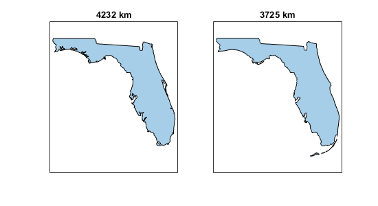
The accuracy of the perimeter function depends on
the resolution of the data used to create the polygons. As a result, the function can return
different results when you use polygon shapes from different data sets as inputs. This image
compares the perimeters of polygon shapes for the state of Florida from two data sets.

Version History
Introduced in R2024a
MATLAB Command
You clicked a link that corresponds to this MATLAB command:
Run the command by entering it in the MATLAB Command Window. Web browsers do not support MATLAB commands.
Web サイトの選択
Web サイトを選択すると、翻訳されたコンテンツにアクセスし、地域のイベントやサービスを確認できます。現在の位置情報に基づき、次のサイトの選択を推奨します:
また、以下のリストから Web サイトを選択することもできます。
最適なサイトパフォーマンスの取得方法
中国のサイト (中国語または英語) を選択することで、最適なサイトパフォーマンスが得られます。その他の国の MathWorks のサイトは、お客様の地域からのアクセスが最適化されていません。
南北アメリカ
- América Latina (Español)
- Canada (English)
- United States (English)
ヨーロッパ
- Belgium (English)
- Denmark (English)
- Deutschland (Deutsch)
- España (Español)
- Finland (English)
- France (Français)
- Ireland (English)
- Italia (Italiano)
- Luxembourg (English)
- Netherlands (English)
- Norway (English)
- Österreich (Deutsch)
- Portugal (English)
- Sweden (English)
- Switzerland
- United Kingdom (English)