[latout,lonout]
= filterm(lat,lon,Z,R,allowed)
filters a set of latitudes and longitudes to include only those data points which have a
corresponding value in Z equal to allowed.
R is a geographic raster reference object.
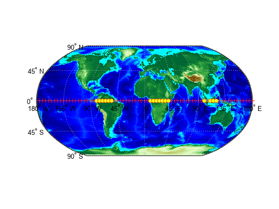
Display points along the equator that are above sea level.
First, load elevation raster data and a geographic cells reference object. The raster contains terrain heights relative to mean sea level. Then, specify the coordinates of evenly spaced points along the equator.
load topo60c
lon = (0:5:360)';
lat = zeros(size(lon));
Create a logical array representing the terrain above sea level. Then, filter the points along the equator to include only the elements that contain true.
Create a world map and display the elevation data. Display the all of the points along the equator using red markers. Then, display the points that are above sea level using yellow circles.
worldmap world
geoshow(topo60c,topo60cR,'DisplayType','texturemap')
demcmap(topo60c)
geoshow(lat,lon,'DisplayType','point','MarkerEdgeColor','r')
geoshow(newlat,newlon,'DisplayType','point','Marker','o',...'MarkerFaceColor','y')
The filterm function does not accept referencing vectors or
referencing matrices as input. Use a geographic raster reference object, specified as a
GeographicCellsReference or GeographicPostingsReference object, as input instead. Reference objects have
several advantages over referencing vectors and referencing matrices.
Unlike referencing vectors and referencing matrices, reference objects have
properties that document the size of the associated raster, its geographic limits, and
the direction of its rows and columns.
You can manipulate the limits of geographic rasters associated with reference
objects using the geocrop
function.
You can manipulate the size and resolution of geographic rasters associated with
reference objects using the georesize
function.
To update your code, create a geographic reference object.
Create a geographic reference object for a raster of cells by using the georefcells function.
Create a geographic reference object for a raster of regularly posted samples by
using the georefpostings function.
Convert from a referencing vector to a geographic reference object by using the
refvecToGeoRasterReference
function.
Convert from a referencing matrix to a geographic reference object by using the
refmatToGeoRasterReference function.
Once you have created a reference object, replace uses of the referencing vector or
referencing matrix in your code with the reference object.
When you specify a referencing vector or referencing matrix as input, the
filterm function issues a warning that it will not accept referencing
vectors or referencing matrices as input in a future release.