gshhs
Read Global Self-Consistent Hierarchical High-Resolution Geography (GSHHG) data
Syntax
Description
S = gshhs(filename)
indexFilename = gshhs(filename,"createindex")indexFilename that enables the
gshhs function to more quickly read subsets of large data sets. Once
you create the index file, the gshhs function uses it to access data by
location.
This syntax does not read the GSHHG data. To read the data after creating the index
file, use the gshhs function again.
Examples
Extract a file containing coarse GSHHG data from a GNU zipped file. Read the file into the workspace as a geographic data structure array.
filename = gunzip("gshhs_c.b.gz");
S = gshhs(filename{1});
Verify that all elements of the structure array represent polygons.
isequal(S.Geometry,"Polygon")ans = logical
1
Query the number of polygons in the structure array.
length(S)
ans =
1866
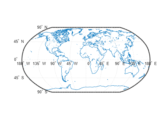
Extract the latitude and longitude coordinates of the polygons from the structure array. Then, display the data using lines on a world map.
lat = [S.Lat];
lon = [S.Lon];

figure
worldmap world
geoshow(lat,lon,"DisplayType","line")
Find the polygons corresponding to land areas (levels == 1) and lakes (levels == 2). Create a map of Europe with the land areas in green and the lakes in blue.
levels = [S.Level];
land = (levels == 1);
lake = (levels == 2);

figure
worldmap europe
geoshow(S(land),"FaceColor","#d2e9b8")
geoshow(S(lake),"FaceColor","b")

Extract a file containing coarse GSHHG data from a GNU zipped file. Create an index for the data.
filename = gunzip("gshhs_c.b.gz");
indexFilename = gshhs(filename{1},"createindex");
Read data for a region surrounding Africa into the workspace as a geographic data structure array. The gshhs function uses the index to more quickly read the data.
latlim = [-40 40];
lonlim = [-20 55];
S = gshhs(filename{1},latlim,lonlim);
Display the data on a world map. To display the lakes and islands within the land areas, sort the structure array in descending order according to the Level field.
[~,ix] = sort([S.Level],"descend");
S = S(ix);

figure
worldmap(latlim,lonlim)
geoshow(S,"FaceColor","#d2e9b8")
setm(gca,"FFaceColor","#9dd7ee")

Input Arguments
Output Arguments
More About
Tips
Mapping Toolbox™ contains the file
gshhs_c.bwithin the GNU zipped filegshhs_c.b.gz. The file contains the coarse data set for version 3 (release 1.3).When you read data within specified limits, the
gshhsfunction does not clip data that is partially within the limits. To clip the data and maintain polygon topology, use themaptrimpfunction and specify the limits as theLatandLonfields contained inS.The
gshhsfunction supports files up to version 15 (releases 1.1 through 2.3.6). The function can also read newer versions, provided they use the same header format as releases 2.0 and 2.1.
Version History
Introduced before R2006a